
Canada's Quality of Life Hub is currently in development. We need your help! If you have ideas or thoughts for what you'd like to see on the Hub, Statistics Canada would love to hear about it. Your input is invaluable as we continue to develop the Quality of Life Hub.
Conserved areas
![]()
Domain
Environment
Subdomain
Ecological integrity and environmental stewardship
Indicator
Conserved areas
Note: This indicator is a headline indicator. Headline indicators are intended to provide a high-level assessment of overall quality of life in Canada.
Description - Conserved areas data snapshot
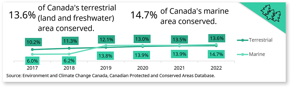
13.6% of Canada's terrestrial (land and freshwater) area conserved.
14,7% of Canada's marine area conserved.
| 2017 | 2018 | 2019 | 2020 | 2021 | 2022 | |
|---|---|---|---|---|---|---|
| Terrestrial | 10.2% | 11.3% | 12.1% | 13.0% | 13.5% | 13.6% |
| Marine | 6.0% | 6.2% | 13.8% | 13.9% | 13.9% | 14.7% |
Source: Environment and Climate Change Canada, Canadian Protected and Conserved Areas Database.
Definition
Amount and proportion of Canada's terrestrial (land and freshwater) and marine area that is recognized as conserved.
Measurement
This indicator measures the amount and proportion of Canada's terrestrial (land and freshwater) and marine area that is recognized as conserved. Conserved areas are lands and waters where human use is limited.
Conserved areas include protected areas as well as other effective area-based conservation measures (OECMs). Protected areas include national, provincial and territorial parks, Indigenous protected areas, national wildlife areas, migratory bird sanctuaries and marine protected areas. OECMs are areas that do not meet the formal definition of protected area but are managed in a way that conserves biodiversity over the long term. Examples of OECMs can include: Indigenous territories, watersheds or resource management areas, and areas with restricted access, such as those used by the military.
The indicator is based on data from the Canadian Protected and Conserved Areas Database. Data from federal, provincial and territorial jurisdictions, the authoritative data sources, are compiled by Environment and Climate Change Canada. The area conserved is estimated by means of a geographical analysis based on reported boundaries, accounting for overlaps. Separate estimates are made for protected areas and OECMs.
Data sources
For key results on conserved areas, please refer to Canada's conserved areas from Environment and Climate Change Canada.
Data visualizations
For visuals of conserved areas data, please refer to Canada's conserved areas from Environment and Climate Change Canada.
- Goal 14, Life Below Water (Sustainable Development Goals, January 25, 2024)
- Goal 15, Life on Land (Sustainable Development Goals, January 25, 2024)
Data analysis
For key results on conserved areas, please refer to Canada's conserved areas from Environment and Climate Change Canada.
Additional information
Well-managed conserved areas are one way to protect wild species and their habitats for present and future generations. Habitat conservation is a measure of human response to the loss of biodiversity and natural habitat. As the area conserved in Canada increases, more lands and waters are withdrawn from direct human development stresses, thereby contributing to biodiversity conservation and improving the health of ecosystems. In turn, healthy ecosystems provide benefits such as clean water, mitigation of climate change, pollination and improved human health.
Frameworks
This indicator aligns with the following frameworks:
- Canadian Indicator Framework (CIF) for the Sustainable Development Goals
- Sustainable Development Goals (SDGs)
- SDG Goal 14 – Life below water
- SDG Indicator 14.5.1 – Coverage of protected areas in relation to marine areas
- SDG Goal 14 – Life below water
- 2022 to 2026 Federal Sustainable Development Strategy (FSDS)
- FSDS Goal 15 – Protect and recover species, conserve Canadian biodiversity
- FSDS Target Indicator – Sustainability of timber harvest
- FSDS Target Indicator – Canada's conserved areas
- FSDS Goal 15 – Protect and recover species, conserve Canadian biodiversity
- Canadian Environmental Sustainability Indicators (CESI)
- Date modified: